The 'Coach Road' is one of the few iconic trails left in Cumbria, it's not technically very difficult, it sees lots of traffic from walkers, cyclists, runners as well as the off-road community, all of whom generally seem to get on well & show a bit of respect for each other... long may that continue!


As I've used this lane a lot over the years whilst participating in several activities enjoying the Cumbrian countryside, I've become intrigued about it's origins & history, so I thought I'd share a bit of what I've found out about it here...
Of course, when you look into one specific area you suddenly find everything is interlinked, so forgive the side trips & rambles as I have found out lots more info about other venues as well as a lot of information about the actual history of the Cumbrian working landscape...
Excerpt taken from the Threlkeld web pages
Threlkeld is the largest settlement along the trail & that village has seen human activity for at least 2,700 years as evidenced by the Iron Age settlement below Threlkeld Knotts. This was a substantial establishment with some 40 hut circles as well as the enclosures above the Quarry.
At that time the valley will have been totally different. There would have been trees covering the valley bottom. There may still have been the remains of a post glacial lake, dammed by the ridge between Wesco and Burns, but now drained by the gorge of the River Greta.
The valley remained heavily wooded until it was cleared for farming and the coming of charcoal burners and sheep. The charcoal burners used the wood (normally by coppicing methods) for smelt and other works, and the sheep prevented re-growth unless they were fenced out of the wooded areas.
The name Threlkeld is Norse and is said to be derived from: "Thrall" - a feudal term for a man bound in service and "keld" a spring or well. Old spellings have been Trellekeld, Threlekelde, and Threlcot.
There is an excellent website that has tried to summarise the various bits of history & information that is floating around into a broad timeline overview, using standard periods of time in history such as the Roman period, the Dark Ages etc... This is called the Industrial History of Cumbria. The Coach Road isn't mentioned particularly but there is a description about a road described as 'another major east-west route from Brougham or Old Penrith to the north to Moresby (Whitehaven) via Keswick (fort yet to located)'. Is this the first mention of the current Coach Road? More investigation needed me thinks...
One things is for sure, there are mines all over this area, there are several quarries that are passed as you traverse the Coach Road & the area is used extensively as an upland grazing area for local farmers sheep. It has been in existence since before Roman times but it is suggested by a friend of mine. who is an Anthropologist and who has studied ancient cultures in the Lakes and specifically the Stone Circle above Keswick.
Her theory is that at the Stone Circle there are 4 larger stones, each one in the direction of the major routes, north to Carlisle, west to Maryport, east to Penrith and south to Ambleside. This would suggest, if its true that the eastward one heads to the Coach Road.
What this does show is an ongoing usage of this working landscape. The quarries are either now abandoned to go back to nature or are now used for climbing & trials/mountain bike practice by the locals, there has been new vegetation & a complete new set of ecology systems that are growing in these unused man affected pieces of landscape. Much like the rest of the UK natural environment really.
Several uses have been suggested for lanes like the Coach Road, as it runs west to east, so from it's early inception, it would have linked the odd village etc, but before the Roman period, there seems to have been actually little need for the local communities to travel as the villages were self sufficient.
However some small tracks were established for various trading needs, mining & seasonal livestock movements etc. The Romans improved the existing trails to facilitate their need to supply forts & the growing number of towns. Maryport, on the west coast was a Roman fort & it's history starts there, geographically at the time, the bottom of the valley would have been forested and boggy, and with poor visibility for attacks, so all the routes tended to be higher up the hillsides. This fits in very well with the way that the Coach Road runs generally above the marshy lower lands that have now been better irrigated and turned into fields.
The Maryport Town Council website has it's own history pages, an excerpt from that states 'The known history of Maryport starts in Roman times with the founding of Alauna, a fort constructed as part of the “Western Sea Defenses” on the Western edge of Hadrian’s Wall. The fort was constructed by legionaries of both the Second and Twentieth legions at some point around 122AD, during the reign of Emperor Hadrian.
The fort was much larger than necessary leading historians to speculate that it may have been the administrative center for the whole of the Western Sea Defenses. It was a close personal friend of Emperor Hadrian, Marcus Maenius Agrippa that was the forts first commander. He commanded first and most frequent roman unit to occupy the fort was the “Cohors 1 Hispanorum Equitata” a five hundred strong part mounted unit recruited from the Roman Spanish provinces.'
As we move inland westwards, Cockermouth is the next main town which owes it's history to the Romans, or more accurately Papcastle... 'Cockermouth owes it existence to the river system. The nearby Roman camp of Dervenitio, modern Papcastle, was situated at the northern end of a crossing of the river Derwent, which flows from east to west just north of the present town centre. Here was an important road junction in the back-up to Hadrian's Wall. Also originating in the central Lakeland fells, the Cocker flows from the south to enter the Derwent here, hence the name of the town. At this confluence grew the normal and medieval settlements, a natural administrative and trading centre for a number of converging valleys'
Continuing west the next main habitation is Keswick, a place I've lived & worked in for nearly 20 years now. Up until starting this little history project, I thought I had a good understanding of the local history of this town, but now I have to be honest & admit I knew very little about it... mmm
Anyhow, back to the history bits... I found out various bits about the Keswick story which actually started with a lesson in geology... Keswick is where it is because it's a mid point on various trading routes, some on water, some over fell roads, some because the local bedrocks provided venues for various mining operations. Skiddaw has lots of mud based slate, there are various ore mines all nearby. The Herdwick Sheep appear to have come from the Norse invasion & the name of Keswick actually means 'Cheese Town', (Amongst some of the things I never knew!!)
The Stone Circle is said to be the origins of Keswick, this overlooks to the west the Coach Road heading towards Penrith, to the south, it looks at Dunmail Raise heading down to Ambleside & Kendal, to the north it is dominated by the mountains of Skiddaw & Blencathra, however sandwiched between the two is the Glendaterra Valley, home to several mines & a lot of upland grazing areas. The Information Britain website gives loads more in-depth info for anybody wanting to know more...
After this we have Threlkeld, then it's on to Penrith, which was a major trading town, apparently over 80,000 sheep were moved through Penrith heading south from Scotland, it also handled the ores & various other commodities that came out of the northern Lakes throughout history.
When you put all of this together it seems fairly obvious to me that the Coach Road grew from a local access track to a major thoroughfare over several hundreds of years. Common sense would surmise that virtually everything from farm goods & animals through to all other kinds of commodity has traveled along this trail at one time or another. But there seems to be very little actual proof specific to this lane, except for vague references, so the question for me still stands alongside the question of it's name, the 'Coach Road', this totally suggests that it was a throughfare.
The problem is that so far this is still all conjecture on my part... more digging needed!
High ground was a natural route choice in the early years, which is why we have the High Street Road, the Walna Scar Road, Gatesgarth Pass etc. The Coach road isn't as high as some of these routes, but it gains a fair amount of height on it's traverse & is an obvious line through the valley. It also reduces the amount of river crossings that could be found in the bottom of the valley, thus removing both a hazard & speed impediment. A really interesting website is the ocd.org site with it's list of highest roads in the UK.
This list has been compiled by it's author based upon the criteria of 'A high road or road pass is a public road historically open to vehicles (vehicles includes pedal bicycles), which connects two valleys, settlements, or other roads, by way of crossing a hill, col, or ridge between. The road must be, or have been, metalled for all, or substantially most, of its length. The minimum height of a ‘high road’ is 1,400 feet, but an historic road pass that is lower may be included if it is of interest to the traveller. Where a high road or pass branches into two or more alternatives, only one shall be listed unless each has a character or name of its own. Where there are alternatives the test shall be applied: highest is best; most historic is best; and rougher is better. The editor’s decision is final. Readers are invited to submit comments and corrections."
I can well guess there will be several people foaming at the mouth about this list but hey, (interestingly this list is compiled on a mountain bike website)...
Another fascinating page on a website that has recorded the history of the southern UK road systems is on the British History Online website, its says:
'Saxon and medieval roads grew gradually and wound from settlement to settlement: old English law concerned roads which, in a 12th-century phrase, led 'from cities to cities, from boroughs to boroughs, by which men go to markets, or about their other affairs'. (fn. 9) For a time the concept of great through routes covering England was almost lost; the tradition of four main roads or 'Streets' on which travellers enjoyed the king's special peace had emerged,'
and also:
'The kings' itineraries and trade records indicate which were the most important routes through the county, but not the exact course of the roads.To a certain extent the course of the roads was determined by the existence of fords and places where it was possible to build bridges.'
Roads that were fit for 'wheeled' vehicles apparently started to appear around the late 18th century as both technology & traffic increased, prior to this Cumbria possessed roads that were described as 'a most confused mixture of rocks and bogs'. That said the roads that have crossed the fells from valley to valley all have old histories, starting with transhumance practices and farmers swapping/returning livestock moving through to military & locals routes.
The Cartographic Perspectives, No 72 (2012) has a good page that even has a poem about roads, whisky & travel on it, but importantly for me is the picture of a more well heeled & romantic horse drawn carriage below.
The Turnpike period is the first time a specific mention of a road between Penrith & Keswick seems to be mentioned. In 1762 a list of Turnpike Roads was complied for Cumbria & this was listed upon. The roads used in this period of time were, for the most part, existing roads, now they were just given an official status within a Trust, that was made responsible for maintenance etc. Modernisation had started & this allowed for routes to be re-routed to suit the new methods of transport for both people & goods. By improving the road surface the travel times were reduced & as a direct result the volume of traffic started to increase... err doesn't all of this sound like something we know a lot about currently???
'Enclosure Roads' appeared in the late 1700's, these had a massive effect upon the landscape & the road network. Essentially, common land was now ring fenced by 'owned' land in a grid pattern, this affected a large proportion of Cumbria & dramatically affected the existing road system, almost as much as the Turnpike process. Ironically the landscape in Cumbria helped to save a totally uniform approach to this, as it only worked on the flatter land & there isn't a lot of that in Cumbria!
The landowners had to rethink the process a little but they just adapted things to suit their needs really, the land that was most accessible & usable came into their ownership & the 'common land' became the upland areas that were more difficult to access & manage. Due to this, fences & gates appeared all over the place & remain today with an ever increasing propensity according to the latest Parliament Amendments.
Since then, it seems things have changed very slowly, the responsibility for the roads has passed to the local authorities, who are cash strapped to say the least, so they are always looking to save money wherever they can. Improvements have been made though with things like the A66 trunk road & the M6 extending to the Scottish Border. The Lakes have been reclassified as a National Park & the Lake District National Park was established
For the Coach Road, it has been reclassified at the moment as an Unclassified Road, It appears to be broken down into two sections & numbered as U2236 & U3132. There are no restrictions on access currently that I'm aware of & it is used by all parties, from walkers to 4x4 enthusiasts. The responsibility for upkeep of it remains with the Highways Authority at the moment, but is heavily influenced by the National Park policies as are all the other 'higher' lanes.
Since the turn of the century the Coach Road was used as a road, unsealed like all the rest at that time. I have been given images of loads of Lakeland lanes that were used for rally events that ran from Scotland to London in 1913 & onwards. The Coach Road was a favorite in these events as was the Garburn Pass, Honister Pass, Walna Scar and all the rest of the high passes. The challenge of ascending them brought hordes of both drivers, riders and spectators to the county. There is a beautiful little film about one such event HERE.
I have heard that there are plans to close this route to mechanised vehicles, a route of choice that the the National Park seems to prefer given the recent history of several of the other fell roads in the National Park.
From my point of view there is no need for this, but then I have to admit that I don't understand the mentality of the UK management processes in general, which appears to be antagonistic to all activities & only sees a benefit in things if there is either a cash benefit or a publicly visual positive slant. 'No' is usually the first answer to any question in this country... Hey hey, rant over!! :-)
Meanwhile, The Coach Road is a great ancient route in the UK, the history, the weather, the landscape & the ever changing panorama makes it endlessly enjoyable for anybody who takes the time to use it & after all whatever it's origins, it always satisfies a need, be that travel, enjoyment or work. What more can you ask for of a man-made edifice?


YouTube Vids of the Coach Road
The Coach Road in the rain - Part 1
The Coach Road in the rain - Part 2
The Coach Road in the sun- C/O MuleKTM
Useful Links for the area:
Penrith
Keswick
Cockermouth
Maryport
Low Todd Rigg - beautiful accommodation near Penruddock
Lake District Trail Routes Information
Update: At the tail end of 2015, Storm Desmond struck and the damage to the Coach Road has been prrety significant... Compare some of the pics to earlier parts of this page.


 This must have happened many times in the past, but it'll be interesting to see what happens about this at the moment as there is so much damage to Cumbria.
NB: I've added links to the relevant pages as I've found more information, this is a bit of a work in progress at the moment, all very adhoc, so it'll grow & pad out in detail as time allows me to do more research, but it's a but dependent upon how much I let loose my naturally geeky nature & how much Lucy takes the pee out of me for being geeky again... (err ask Lucy about road surfaces if you meet her!! :-)...). Anyway, I've left the comments bit open on his post for once, so if you know much about this lane or know where i can find more specific info I'd be interested to have a look, especially at some of the old maps, which might require a visit to the council offices one day... hey ho... have fun....


As I've used this lane a lot over the years whilst participating in several activities enjoying the Cumbrian countryside, I've become intrigued about it's origins & history, so I thought I'd share a bit of what I've found out about it here...
Of course, when you look into one specific area you suddenly find everything is interlinked, so forgive the side trips & rambles as I have found out lots more info about other venues as well as a lot of information about the actual history of the Cumbrian working landscape...
Excerpt taken from the Threlkeld web pages
Threlkeld is the largest settlement along the trail & that village has seen human activity for at least 2,700 years as evidenced by the Iron Age settlement below Threlkeld Knotts. This was a substantial establishment with some 40 hut circles as well as the enclosures above the Quarry.
 |
| Threlkeld Village from the Coach Road |
The valley remained heavily wooded until it was cleared for farming and the coming of charcoal burners and sheep. The charcoal burners used the wood (normally by coppicing methods) for smelt and other works, and the sheep prevented re-growth unless they were fenced out of the wooded areas.
The name Threlkeld is Norse and is said to be derived from: "Thrall" - a feudal term for a man bound in service and "keld" a spring or well. Old spellings have been Trellekeld, Threlekelde, and Threlcot.
There is an excellent website that has tried to summarise the various bits of history & information that is floating around into a broad timeline overview, using standard periods of time in history such as the Roman period, the Dark Ages etc... This is called the Industrial History of Cumbria. The Coach Road isn't mentioned particularly but there is a description about a road described as 'another major east-west route from Brougham or Old Penrith to the north to Moresby (Whitehaven) via Keswick (fort yet to located)'. Is this the first mention of the current Coach Road? More investigation needed me thinks...
One things is for sure, there are mines all over this area, there are several quarries that are passed as you traverse the Coach Road & the area is used extensively as an upland grazing area for local farmers sheep. It has been in existence since before Roman times but it is suggested by a friend of mine. who is an Anthropologist and who has studied ancient cultures in the Lakes and specifically the Stone Circle above Keswick.
Her theory is that at the Stone Circle there are 4 larger stones, each one in the direction of the major routes, north to Carlisle, west to Maryport, east to Penrith and south to Ambleside. This would suggest, if its true that the eastward one heads to the Coach Road.
What this does show is an ongoing usage of this working landscape. The quarries are either now abandoned to go back to nature or are now used for climbing & trials/mountain bike practice by the locals, there has been new vegetation & a complete new set of ecology systems that are growing in these unused man affected pieces of landscape. Much like the rest of the UK natural environment really.
Several uses have been suggested for lanes like the Coach Road, as it runs west to east, so from it's early inception, it would have linked the odd village etc, but before the Roman period, there seems to have been actually little need for the local communities to travel as the villages were self sufficient.
However some small tracks were established for various trading needs, mining & seasonal livestock movements etc. The Romans improved the existing trails to facilitate their need to supply forts & the growing number of towns. Maryport, on the west coast was a Roman fort & it's history starts there, geographically at the time, the bottom of the valley would have been forested and boggy, and with poor visibility for attacks, so all the routes tended to be higher up the hillsides. This fits in very well with the way that the Coach Road runs generally above the marshy lower lands that have now been better irrigated and turned into fields.
The Maryport Town Council website has it's own history pages, an excerpt from that states 'The known history of Maryport starts in Roman times with the founding of Alauna, a fort constructed as part of the “Western Sea Defenses” on the Western edge of Hadrian’s Wall. The fort was constructed by legionaries of both the Second and Twentieth legions at some point around 122AD, during the reign of Emperor Hadrian.
The fort was much larger than necessary leading historians to speculate that it may have been the administrative center for the whole of the Western Sea Defenses. It was a close personal friend of Emperor Hadrian, Marcus Maenius Agrippa that was the forts first commander. He commanded first and most frequent roman unit to occupy the fort was the “Cohors 1 Hispanorum Equitata” a five hundred strong part mounted unit recruited from the Roman Spanish provinces.'
As we move inland westwards, Cockermouth is the next main town which owes it's history to the Romans, or more accurately Papcastle... 'Cockermouth owes it existence to the river system. The nearby Roman camp of Dervenitio, modern Papcastle, was situated at the northern end of a crossing of the river Derwent, which flows from east to west just north of the present town centre. Here was an important road junction in the back-up to Hadrian's Wall. Also originating in the central Lakeland fells, the Cocker flows from the south to enter the Derwent here, hence the name of the town. At this confluence grew the normal and medieval settlements, a natural administrative and trading centre for a number of converging valleys'
Continuing west the next main habitation is Keswick, a place I've lived & worked in for nearly 20 years now. Up until starting this little history project, I thought I had a good understanding of the local history of this town, but now I have to be honest & admit I knew very little about it... mmm
Anyhow, back to the history bits... I found out various bits about the Keswick story which actually started with a lesson in geology... Keswick is where it is because it's a mid point on various trading routes, some on water, some over fell roads, some because the local bedrocks provided venues for various mining operations. Skiddaw has lots of mud based slate, there are various ore mines all nearby. The Herdwick Sheep appear to have come from the Norse invasion & the name of Keswick actually means 'Cheese Town', (Amongst some of the things I never knew!!)
The Stone Circle is said to be the origins of Keswick, this overlooks to the west the Coach Road heading towards Penrith, to the south, it looks at Dunmail Raise heading down to Ambleside & Kendal, to the north it is dominated by the mountains of Skiddaw & Blencathra, however sandwiched between the two is the Glendaterra Valley, home to several mines & a lot of upland grazing areas. The Information Britain website gives loads more in-depth info for anybody wanting to know more...
 |
| The Stone Circle at Castlerigg |
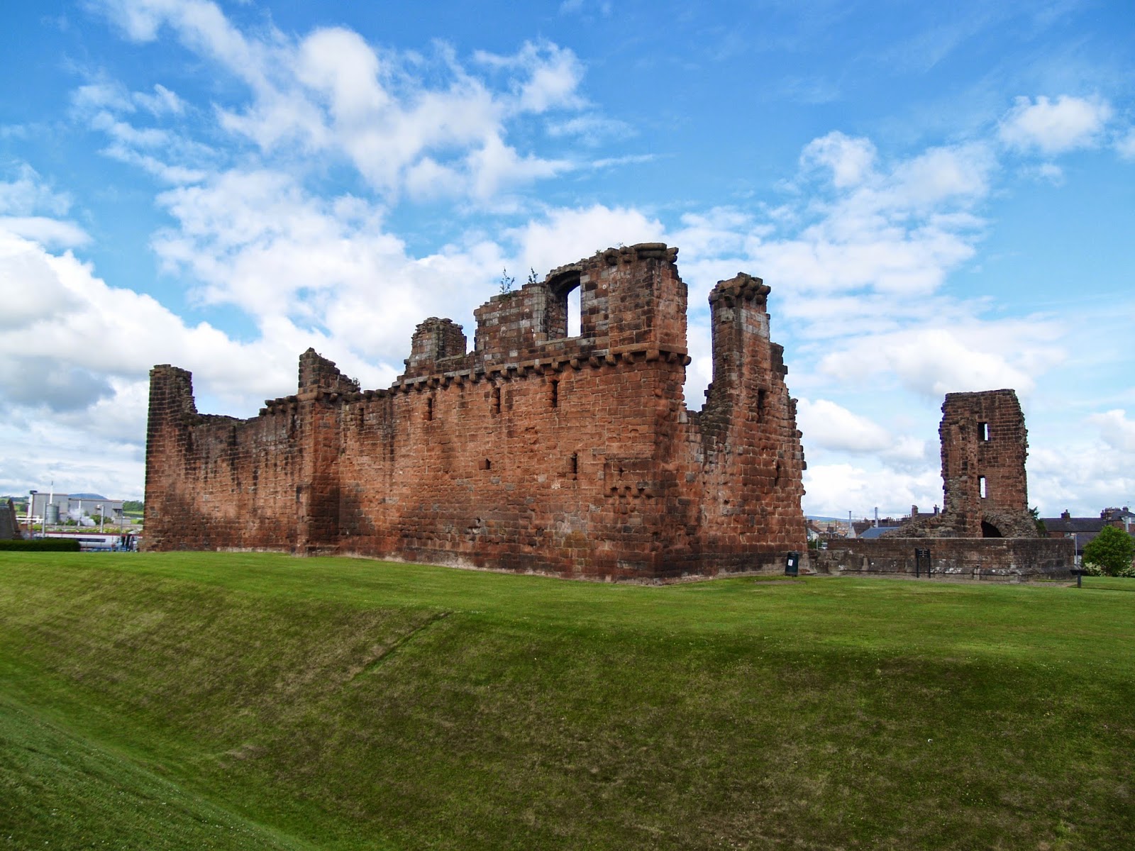 |
| Penrith Castle ruins |
The problem is that so far this is still all conjecture on my part... more digging needed!
High ground was a natural route choice in the early years, which is why we have the High Street Road, the Walna Scar Road, Gatesgarth Pass etc. The Coach road isn't as high as some of these routes, but it gains a fair amount of height on it's traverse & is an obvious line through the valley. It also reduces the amount of river crossings that could be found in the bottom of the valley, thus removing both a hazard & speed impediment. A really interesting website is the ocd.org site with it's list of highest roads in the UK.
This list has been compiled by it's author based upon the criteria of 'A high road or road pass is a public road historically open to vehicles (vehicles includes pedal bicycles), which connects two valleys, settlements, or other roads, by way of crossing a hill, col, or ridge between. The road must be, or have been, metalled for all, or substantially most, of its length. The minimum height of a ‘high road’ is 1,400 feet, but an historic road pass that is lower may be included if it is of interest to the traveller. Where a high road or pass branches into two or more alternatives, only one shall be listed unless each has a character or name of its own. Where there are alternatives the test shall be applied: highest is best; most historic is best; and rougher is better. The editor’s decision is final. Readers are invited to submit comments and corrections."
I can well guess there will be several people foaming at the mouth about this list but hey, (interestingly this list is compiled on a mountain bike website)...
Another fascinating page on a website that has recorded the history of the southern UK road systems is on the British History Online website, its says:
'Saxon and medieval roads grew gradually and wound from settlement to settlement: old English law concerned roads which, in a 12th-century phrase, led 'from cities to cities, from boroughs to boroughs, by which men go to markets, or about their other affairs'. (fn. 9) For a time the concept of great through routes covering England was almost lost; the tradition of four main roads or 'Streets' on which travellers enjoyed the king's special peace had emerged,'
and also:
'The kings' itineraries and trade records indicate which were the most important routes through the county, but not the exact course of the roads.To a certain extent the course of the roads was determined by the existence of fords and places where it was possible to build bridges.'
Roads that were fit for 'wheeled' vehicles apparently started to appear around the late 18th century as both technology & traffic increased, prior to this Cumbria possessed roads that were described as 'a most confused mixture of rocks and bogs'. That said the roads that have crossed the fells from valley to valley all have old histories, starting with transhumance practices and farmers swapping/returning livestock moving through to military & locals routes.
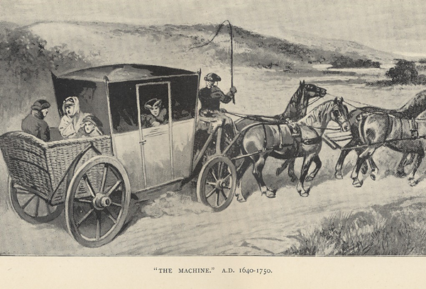
The Cartographic Perspectives, No 72 (2012) has a good page that even has a poem about roads, whisky & travel on it, but importantly for me is the picture of a more well heeled & romantic horse drawn carriage below.

The Turnpike period is the first time a specific mention of a road between Penrith & Keswick seems to be mentioned. In 1762 a list of Turnpike Roads was complied for Cumbria & this was listed upon. The roads used in this period of time were, for the most part, existing roads, now they were just given an official status within a Trust, that was made responsible for maintenance etc. Modernisation had started & this allowed for routes to be re-routed to suit the new methods of transport for both people & goods. By improving the road surface the travel times were reduced & as a direct result the volume of traffic started to increase... err doesn't all of this sound like something we know a lot about currently???
'Enclosure Roads' appeared in the late 1700's, these had a massive effect upon the landscape & the road network. Essentially, common land was now ring fenced by 'owned' land in a grid pattern, this affected a large proportion of Cumbria & dramatically affected the existing road system, almost as much as the Turnpike process. Ironically the landscape in Cumbria helped to save a totally uniform approach to this, as it only worked on the flatter land & there isn't a lot of that in Cumbria!
The landowners had to rethink the process a little but they just adapted things to suit their needs really, the land that was most accessible & usable came into their ownership & the 'common land' became the upland areas that were more difficult to access & manage. Due to this, fences & gates appeared all over the place & remain today with an ever increasing propensity according to the latest Parliament Amendments.
Since then, it seems things have changed very slowly, the responsibility for the roads has passed to the local authorities, who are cash strapped to say the least, so they are always looking to save money wherever they can. Improvements have been made though with things like the A66 trunk road & the M6 extending to the Scottish Border. The Lakes have been reclassified as a National Park & the Lake District National Park was established
For the Coach Road, it has been reclassified at the moment as an Unclassified Road, It appears to be broken down into two sections & numbered as U2236 & U3132. There are no restrictions on access currently that I'm aware of & it is used by all parties, from walkers to 4x4 enthusiasts. The responsibility for upkeep of it remains with the Highways Authority at the moment, but is heavily influenced by the National Park policies as are all the other 'higher' lanes.
Since the turn of the century the Coach Road was used as a road, unsealed like all the rest at that time. I have been given images of loads of Lakeland lanes that were used for rally events that ran from Scotland to London in 1913 & onwards. The Coach Road was a favorite in these events as was the Garburn Pass, Honister Pass, Walna Scar and all the rest of the high passes. The challenge of ascending them brought hordes of both drivers, riders and spectators to the county. There is a beautiful little film about one such event HERE.
I have heard that there are plans to close this route to mechanised vehicles, a route of choice that the the National Park seems to prefer given the recent history of several of the other fell roads in the National Park.
From my point of view there is no need for this, but then I have to admit that I don't understand the mentality of the UK management processes in general, which appears to be antagonistic to all activities & only sees a benefit in things if there is either a cash benefit or a publicly visual positive slant. 'No' is usually the first answer to any question in this country... Hey hey, rant over!! :-)
Meanwhile, The Coach Road is a great ancient route in the UK, the history, the weather, the landscape & the ever changing panorama makes it endlessly enjoyable for anybody who takes the time to use it & after all whatever it's origins, it always satisfies a need, be that travel, enjoyment or work. What more can you ask for of a man-made edifice?


YouTube Vids of the Coach Road
The Coach Road in the rain - Part 1
The Coach Road in the rain - Part 2
The Coach Road in the sun- C/O MuleKTM
Useful Links for the area:
Penrith
Keswick
Cockermouth
Maryport
Low Todd Rigg - beautiful accommodation near Penruddock
Lake District Trail Routes Information
Update: At the tail end of 2015, Storm Desmond struck and the damage to the Coach Road has been prrety significant... Compare some of the pics to earlier parts of this page.


NB: I've added links to the relevant pages as I've found more information, this is a bit of a work in progress at the moment, all very adhoc, so it'll grow & pad out in detail as time allows me to do more research, but it's a but dependent upon how much I let loose my naturally geeky nature & how much Lucy takes the pee out of me for being geeky again... (err ask Lucy about road surfaces if you meet her!! :-)...). Anyway, I've left the comments bit open on his post for once, so if you know much about this lane or know where i can find more specific info I'd be interested to have a look, especially at some of the old maps, which might require a visit to the council offices one day... hey ho... have fun....